Developing open Earth observation tools for ecosystem restoration assessment and monitoring

Pioneer Earth Observation apPlications for the Environment - Ecosystem Restoration (PEOPLE-ER)

Approach

Analytics

PEOPLE-ER is financed under the Earth Observation Science for Society (EO4Society)  programmatic element of FutureEO-1.

PEOPLE-ER is one of four related pioneer projects with the objective to develop innovative high-quality EO-based application products, indicators and methods, targeting specific high-priority research and development (R&D) matters raised by the international environment policy agenda and with a distinct connection to the European Union (EU) Green Deal.

PEOPLE-ER commenced in October 2022 and will be completed at the end of April 2024.

Solutions

PEOPLE-ER addresses the needs of forest landscape restoration and wetland restoration initiatives around the world.
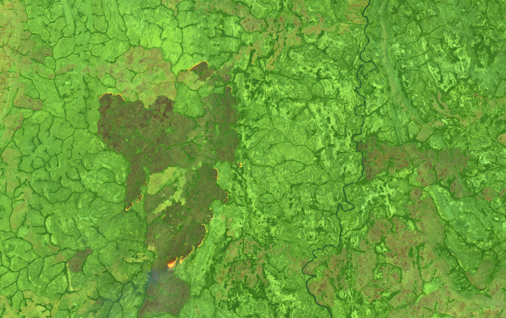
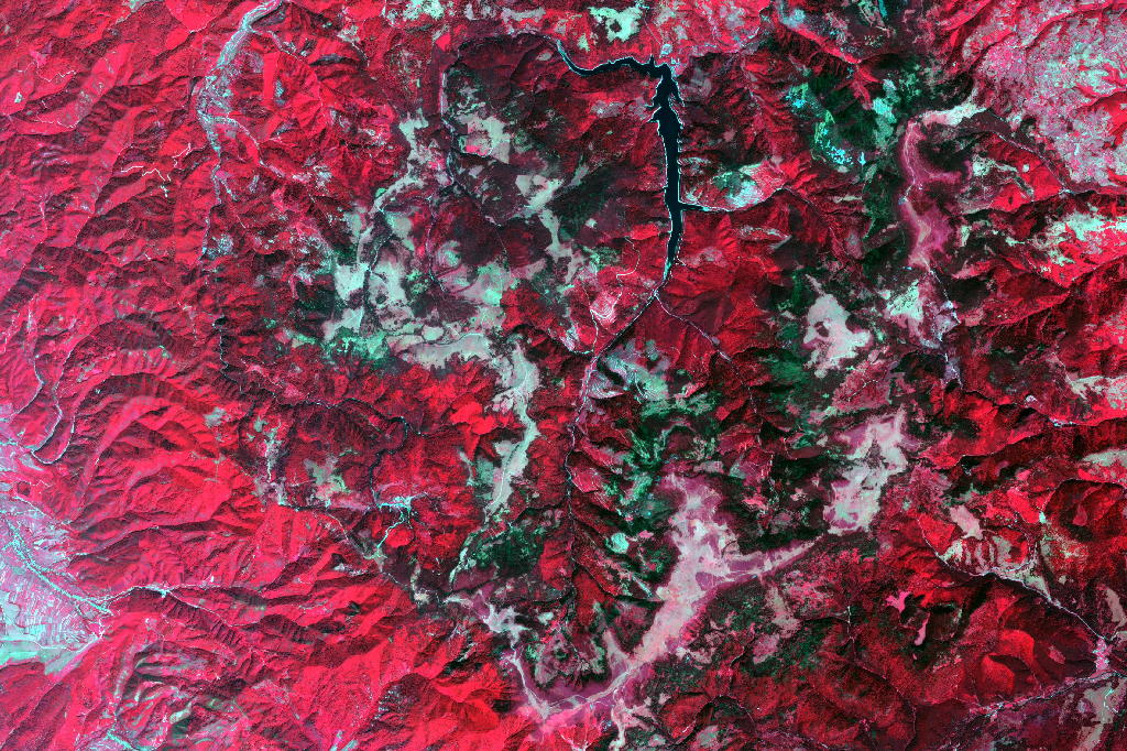
noun_Elm Trees_631497

Spectral Recovery

Provides automated analysis of Sentinel-2 and Landsat satellite EO data time series to enable monitoring of vegetation recovery in forested ecosystems from boreal to tropical biomes.

Spectral Recovery is an open source and multi-platform EO time series data analytics solution for restoration monitoring and assessment. It provides flexible methods for spectral recovery analysis by allowing users to select from a variety of spectral indices and recovery metrics as well as define reference or baseline conditions.

Codebase and documentation:

Hosted on the Forestry Thematic Exploitation Platform for users who prefer a solution with graphic interface.

noun_reeds_625772

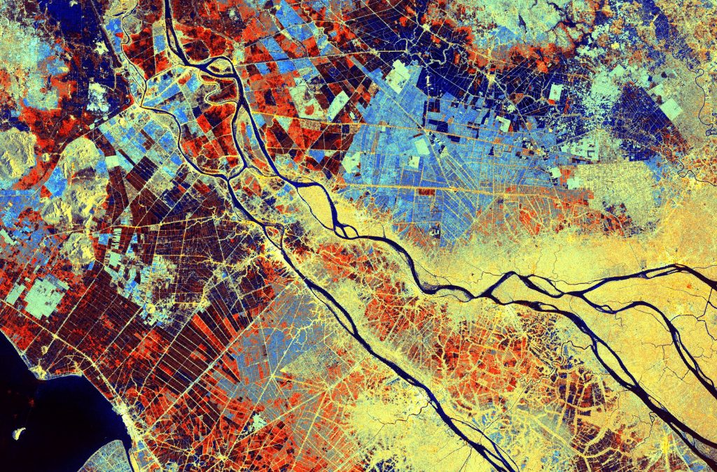
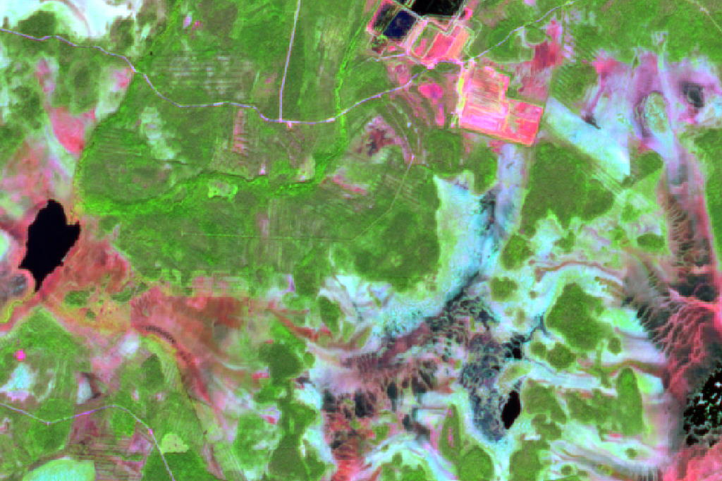
Satellite Wetland Inundation Flood Time-series Clustering (SWIFT-C)

Provides methods for analysis of Sentinel-1 radar EO data time series to detect changes in inundation dynamics in natural to heavily modified wetland ecosystems. 

SWIFT-C is an open methodology that includes:

  1. Landscape structure analysis
  2. Full Sentinel-1 time-series compositing to 10-day series
  3. Visualize the similarity of temporal patterns in the radar time series
  4. Clustering and classification of the time series to identify wetland inundation functions

Codebase and documentation:

noun_Elm Trees_631497

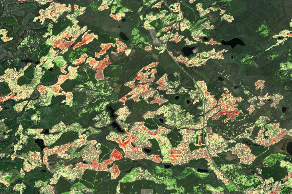
k-NN forest structure variables

Enables wall-to-wall prediction of target variables of interest using field reference data and selected EO datasets.

K-NN is an open source tool for deriving forest structural variable maps by combining field reference data and EO datasets. It provides means to map ecosystem characteristics at any given timepoint before or during restoration.

Codebase and documentation:

Hosted on the Forestry Thematic Exploitation Platform for users who prefer a solution with graphic interface.

Demonstrations with Early Adopters

Mekong Delta, Vietnam

Vietnam’s upper Mekong Delta is susceptible to extreme floods and droughts. IUCN is supporting an initiative to transition away from a third annual rice crop into nature-based solutions (NBS) of flood-based agriculture. This includes ending investment in high dikes, which prevent flooding from the Mekong River, and enabling floodplain reconnection. 

To contribute to policy implementation, IUCN requires information on flood extent, floodplain connectivity, and flood-based crop extent.

The objective was to identify restoration areas that are open to the natural ‘flood pulse’ and areas still protected by high dikes.

The radar-based SWIFT-C workflow was used to assess the transition from 2018 to 2022. The analysis showed a 22% decrease in the total area of triple rice, which helped IUCN Vietnam and their partners to understand the progress in the transition to flood-based agriculture.

Vietnam demonstration summary report

British Columbia, Canada

In North Central BC, forest ecosystems are impacted by the cumulative effects of mountain pine beetle, wildfire, forest harvesting, and energy operations. Monitoring forest recovery following disturbance is a critical information need. 

The objective was to assess forest recovery across a landscape using standard recovery metrics derived from Landsat and Sentinel-2 time series, to identify areas that are recovered, recovering as expected, or potentially need management intervention.

The demonstration assessed novel functionality provided by the Spectral Recovery tool to compare 1) setting recovery targets using historical value or reference sites; 2) Sentinel-2 compared to Landsat time series; and 3) single pixel-, multi-pixel-, and polygon-based analysis.

BC demonstration summary report

Chinko Conservation Area, Central African Republic

Chinko Conservation Area in Central African Republic (CAR) is a mosaic of different ecosystems, incredibly rich with a unique composition of biodiversity and opportunities for ecological and evolutionary processes. Key threats include regional insecurity, weak governance, cross border infringement and high levels of poverty among both local sedentary and nomadic populations.

African Parks ecosystem restoration and protection interventions in Chinko include expanding the area free of cattle to reverse habitat degradation.

The objective was to assess vegetation recovery in Chinko’s woodland savanna between 2017-2023 using  a spectral recovery method suitable for monitoring in a highly seasonal landscape.

CAR demonstration summary report

Finland

Natural Resources Institute Finland (Luke) is collaborating with the Parks & Wildlife Finland (Metsähallitus) on monitoring the progression of peatland restoration sites in northern Finland. Luke is developing new approaches and solutions for practical implementation of the monitoring.

The objective was to reduce the amount of field work and increase the spatio-temporal detail of monitoring of the restoration sites and surrounding areas with spectral trend analysis and k-NN vegetation structure mapping.

The results indicate that the tools are applicable for change alerting and estimation of vegetation attributes in restored and unrestored peatland areas. The revegetation on abandoned peat extraction areas is detectable, but subtle trends in restored peatlands are more challenging to detect.

Romania

National Institute for Research and Development in Forestry in Romania (INCDS) conducts research to improve understanding about the impact of restoration activities for both the forest restoration sites and the surrounding areas.

INCDS urgently need tools to enable efficient monitoring of the progress of forest restoration activities and quantification of ecological and climate effects of forest disturbances and subsequent recovery.

The objective was to assess the spectral recovery and k-NN tools to address the need for a landscape-scale monitoring solution and to provide estimates of structural parameters before and after disturbances, and during recovery.

Romania demonstration summary report

Platforms

The strategy chosen in the PEOPLE-ER project aims to meet the needs of the full range of users by catering to varying levels of background experience on using EO and cloud platforms. The Spectral Recovery and K-NN solutions were made available on the Forestry TEP.

All three solutions are available under FAIR principles with the Python codebases of the tools in GitHub (with extensive documentation and tutorials) which enables expert users to integrate the tools into their preferred platform or computing environment. 

Forestry TEP

  • Access satellite imagery, ancillary datasets, and ready-made products 
  • Thematic processing services and supporting processing services

Python Codebase

  • PEOPLE-ER GitHub
  • Demonstration of suitability in platforms such as Microsoft Planetary Computer and the Copernicus Data Access Service

Reports and Presentations

The project outputs will include algorithms available via public code repositories, notebooks for implementation in cloud platforms, user documentation, and scientific publications. 

Presentations & Webinar

Presentation: GEO BON Global Conference: Monitoring Biodiversity for Action

Montreal Oct 9-13th 2023 

Open EO tools for terrestrial vegetation and wetland function recovery analysis to support ecosystem and biodiversity restoration projects. 

Webinar: Spectral Recovery – Empowering Ecosystem Restoration Monitoring with an Open Remote Sensing Package

An overview of the open-source Python package, Spectral Recovery. Researchers in the Integrated Remote Sensing Studio (IRSS) at the University of British Columbia explore the theory behind using satellite data to inform on forest conditions, dive into the innovative and customizable features of the tool, with a demonstration showing how it can aid in monitoring and measuring forest ecosystem recovery.

Workshop: European Geosciences Union (EGU) General Assembly 2024

Presentation and discussion of the open Spectral Recovery tool for forest restoration monitoring, with use cases in Finland, Romania, and Canada. 

Wednesday 17 Apr, 10:45 am to 12:30 pm (CEST)

Splinter Meeting SPM67

Room 2.43

Presentation:

Monitoring forest disturbance recovery using metrics derived from multi-spectral satellite time-series: introducing the spectral recovery open-source package with European and Canadian use cases.

Melissa Birch, Sarah Zwiep, Nicholas C. Coops, Andy Dean, Marcos Kavlin, and Frank Martin Seifert

Friday 19 April, 12:00 to 12:10 pm (CEST)

Abstract

Session BG3.9

Room 2.17

Our team

Contact us

    Consortium Members

    Hatfield is a science-driven service-oriented company that builds solutions to complex environmental challenges, with a depth of experience in ecosystem restoration projects in Canada and around the world. Hatfield is a trusted partner for the development of cutting-edge and practical EO technologies.

    The remote sensing team at VTT Technical Research Centre of Finland produces EO data processing chains for domestic and international users. The team is internationally known, particularly for its forest monitoring applications and the Forestry TEP cloud processing platform. VTT is ranked among the leading European Research and Technology Organisations.

    Dr. Nicholas Coops leads the Integrated Remote Sensing Studio (IRSS) at the University of British Columbia, a leading international research group in the application of EO technologies for forest ecosystem assessment and monitoring. This includes ER and the prioritization of methods and products for remote sensing essential biodiversity variables (RS-EBVs).

    Early Adopters

    INCDS is the main organisation of research and development in forestry from Romania. INCDS is in charge for the forest resources assessment and monitoring in Romania through National Forest Inventory. INCDS has also secured the support of two Romanian NGOs as documented in letters of support: Forestry Society Association and Fundatia Grupul Verde Oradea.

    As one of the biggest clusters of bioeconomy expertise in Europe, Luke develops knowledge-based solution models and services for renewable natural resources management and supports decision-making in society.

    African Parks is a leading non-profit conservation organisation that takes on the complete responsibility for the rehabilitation and long-term management of protected areas across Africa in partnership with governments and local communities.

    African Parks currently manages 19 national parks and protected areas in 11 countries covering over 14.7 million hectares. African Parks is rapidly growing, aiming to directly manage 30 protected areas by 2030, across 11 biomes, measuring 30 million hectares contributing to the global target of protecting 30% of the Earth to keep the planet flourishing.

    Established in 1948, IUCN is an international authority working on a wide range of themes related to nature conservation, forests, ecosystem management, protected areas, global policy and governance and rights.

    IUCN Vietnam was established in 1993 as an IUCN State member. Since then, IUCN has made important contribution to biodiversity conservation and environmental protection in Vietnam.

    SERNbc is a key enabler for ecosystem restoration in forested ecosystems in northern British Columbia affected by cumulative disturbances from forest operations, energy exploration, wildfires, and forest pests/diseases.

    Scroll to top